-
About Homer
-
- Americans with Disabilities Act Compliance Program City Campgrounds Community Recreation Hickerson Memorial Cemetery
- Library Parks & Trails Public Safety Fire Police Emergency Information
- Events & Activities City Calendar Library Calendar Recreation Calendar Doing Business in Homer Sister City Program Coast Guard City
-
- Departments
- Government
- How Do I?

Be Tsunami Aware. Be Tsunami Prepared. Know Homer's Evacuation Routes and Safe Zones
|
Many of us live, work, shop or play in Homer's tsunami danger zone. Tsunamis don't happen often, but preparing now could save your life. Knowing Homer's tsunami inundations zones and where to go during a tsunami evacuation ahead of time is crucial to your survival--you may only have minutes to get to safety. Learn the tsunami warning signs and how to respond -- it can save your life! |
Know Homer's Tsunami Inundation Zones
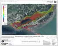 |
Recent maps (click map at left or see file attached below) published by the Alaska Earthquake Center put Homer's maximum inundation height at 50 feet. If you are below 50 feet in elevation you are in the danger zone and should evacuate immediately to higher ground if you get a tsunami warning sign. |
You can determine if where you live, work or play is in the danger zone in two ways:
- Find your location on the maps below or on the interactive tsunami inundation map on the Alaska Earthquake Center's website. The interactive website map includes both flow depths and inundation boundaries.
- The Homer Police Department, upon request, will pay a visit and determine your property's elevation. To set up a visit, call HPD at 235-3150.
Know The Tsunami Warning Signs
If you are in a tsunami hazard zone and receive an official warning or if you notice natural signs of a tsunami, evacuate immediately to high ground. Earthquakes can trigger an underwater landslide in Kachemak Bay, giving you minutes rather than hours to reach safety.
Tsunami sirens and evacuation messages are official warnings. You can also receive official emergency alerts from the Kenai Peninsula Office of Emergency Management on your cell phone by signing up at alerts.kpb.us.
Learn about the different kinds of warning signs by reading the tsunami warning signs attachment below.
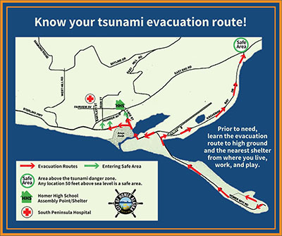
Know Homer's Tsunami Evacuation Routes
A map of Homer's evacuation routes are attached below. Actual routes are marked with official blue and white Tsunami Evacuation Route road signs.
- From the Homer Spit proceed immediately inland on Homer Spit Road. Turn right (east) on Kachemak Drive. Proceed all the way east on Kachemak Drive to East End Road.
- From areas south of Beluga Slough, proceed to Kachemak Drive and evacuate east on Kachemak Drive to East End Road.
- From areas north of Beluga Slough, proceed north on Lake Street, Heath Street or other north-south connector roads toward Pioneer Avenue. Pioneer Avenue is well above the tsunami inundation zone.
How to Stay Safe Before, During and After a Tsunami
During a Tsunami evacuation, it's important to quickly get to and stay at high ground until authorities issue the all-clear. A tsunami is not one big wave, it is a series of inundations. People in the past have had injuries or loss of life because the first wave comes in and people go back home, and then the second, often bigger wave comes.
Click on the attachment below for a brief overview of how to stay safe when a tsunami threatens.
What If I'm In My Boat?
General recommendations from the Alaska Earthquake Center, National Tsunami Hazard Mitigation Program and the US Coast Guard is that boaters do NOT take vessels offshore before or during a tsunami event because you could put yourself at greater risk to injury.
However, if conditions permit and you do decide to go offshore, proceed to a staging area greater than 30 fathoms (180 ft) & at least 1/2 mile from shore and have the experience, fuel, and supplies to stay offshore for more than 24 hours or possibly have the resources to travel to a different port if extensive damage occurs to your home port.
Monitor VHF FM Channel 16 and the marine WX channels for periodic updates of tsunami and general weather conditions; additional information will be available from NOAA Weather Radio.
If conditions do not permit, dock your boat and get out of the Tsunami Evacuation Zone.
If you are already offshore at less than 100 fathoms (600 ft):
(1) Stop fishing operations immediately
(2) free the vessel from any bottom attachment (cut lines if necessary), and
(3) if you can, beach or dock your boat and evacuate on foot within 10 minutes of a natural warning, then this is your best chance. If that is not possible, head to greater than 100 fathoms, keeping in mind the following:
- Proceed as perpendicular to shore as possible.
- Sail directly into wind waves, keeping in mind that wind waves opposed by tsunami currents will be greatly amplified.
- Maintain as much separation as possible from other vessels.
- Synchronize movements with other vessels to avoid collisions.
Do not re-enter the harbor until the harbor master or port captain indicates it is safe to do so. See attachment below for full recommendations.
Know Your Tsunami Hazard in Homer
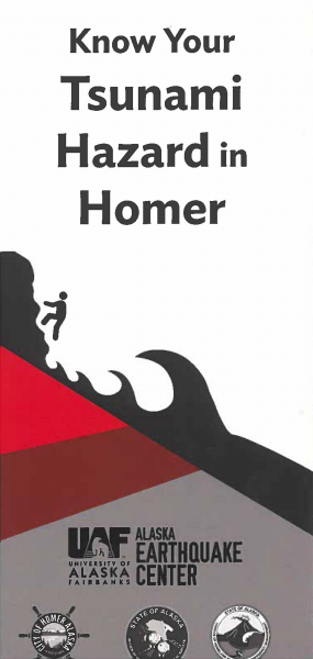 |
Knowing your risk before disaster hits could save your life. Explore the online tool at tsunami.alaska.edu to determine whether your house, workplace, or school is in the inundation/flood zone. Click here to view the Know Your Tsunami Hazard in Homer brochure. |