-
About Homer
-
- Americans with Disabilities Act Compliance Program City Campgrounds Community Recreation Hickerson Memorial Cemetery
- Library Parks & Trails Public Safety Fire Police Emergency Information
- Events & Activities City Calendar Library Calendar Recreation Calendar Doing Business in Homer Sister City Program Coast Guard City
-
- Departments
- Government
- How Do I?

Check Out the New Interactive Maps on the City's Website
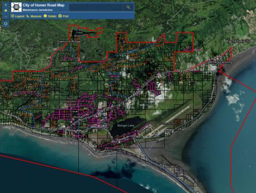
The City of Homer recently upgraded the maps on the City’s website! They are now available on an interactive web app platform hosted by ArcGIS online.
The new Public Works and Parks & Recreation maps have the same content; but, unlike the previous PDF maps, the new platform gives citizens more tools like search queries, popup information and printing features to make finding information a whole lot easier. Also, aerial imagery is used as the base of the maps (which is fairly up to date for Alaska standards) and is navigable to any extent, further enhancing user orientation and location finding.
One new addition to the online map collection is the Hickerson Memorial Cemetery, which includes detailed plot information and the recent block expansion. The new maps can be found by following the web links in their respective department categories, or try them out by clicking the links below:
Hornaday Park Campground Map https://www.cityofhomer-ak.gov/recreation/hornaday-park-campground
Hickerson Memorial Cemetary Map https://www.cityofhomer-ak.gov/cityclerk/hickerson-memorial-cemetery
Public Works Maps https://www.cityofhomer-ak.gov/publicworks/maps